
arcgis api for js入门开发系列十三地图最短路径分析 - GIS之家
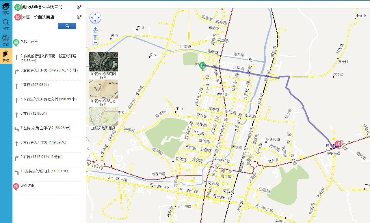
上一篇实现了demo的地图打印,本篇新增地图最短路径分析,截图如下: 具体实现的思路如下: 1.点击地图获取地名,调用了arcgis的地理编码服务,关于地理编码服务制作以及发布章节,感兴趣的请查看这里 点击地图获取地名的核心js代码: DCI.Ro...
- 作者:来源:|2017年09月07日
上一篇实现了demo的地图打印,本篇新增地图最短路径分析,截图如下:
具体实现的思路如下:
1.点击地图获取地名,调用了ARCGIS的地理编码服务,关于地理编码服务制作以及发布章节,感兴趣的请查看这里
点击地图获取地名的核心js代码:
DCI.Route.locator = new esri.tasks.Locator(MapConfig.locatorUrl);
DCI.Route.drawtool = new esri.toolbars.Draw(map, { showTooltips: true });
DCI.Route.drawtool.on("draw-end", DCI.Route.addToMap);

//起点位置添加事件
$("#point1").bind("click", function (event) {
                DCI.Route.pointlayer.clear();
                DCI.Route.map.graphics.clear();
                DCI.Route.routeParams.stops.features = [];
                $("#routeStar").val("");
                $("#routeEnd").val("");
                DCI.Route.flag = true;

                DCI.Route.map.setMapCursor('crosshair');
                DCI.Route.drawtool.activate(esri.toolbars.Draw.POINT);
})
//终点位置添加事件
$("#point2").bind("click", function (event) {
                DCI.Route.flag = false;
                DCI.Route.map.setMapCursor('crosshair');
                DCI.Route.drawtool.activate(esri.toolbars.Draw.POINT);
})

    /*
     *根据坐标点获取地名
     */
    addToMap: function (evt) {
        if (DCI.Route.flag)
            var stopSymbol = new esri.symbol.PictureMarkerSymbol(getRootPath() + "Content/images/route/NAStartLocx.png", 29, 30);
        else
            var stopSymbol = new esri.symbol.PictureMarkerSymbol(getRootPath() + "Content/images/route/NAEndLocx.png", 29, 30);
        var graphic = new esri.Graphic(evt.geometry, stopSymbol);
        //DCI.Route.map.graphics.add(graphic);
        DCI.Route.pointlayer.add(graphic);
        DCI.Route.drawtool.deactivate();
        DCI.Route.map.setMapCursor('auto');
        DCI.Route.locator.locationToAddress(evt.geometry, 500, DCI.Route.GetAddress, DCI.Route.GetAddresserror);
    },
    /*
     *获取地名
     */
    GetAddress: function (evt) {
        if (DCI.Route.flag)
            $("#routeStar").val(evt.address.SingleKey);
        else
            $("#routeEnd").val(evt.address.SingleKey);
    }
2.最短分析实现的思路,就是设置路径分析函数执行的参数routeParams
DCI.Route.routeTask = new esri.tasks.RouteTask(MapConfig.routetaskUrl);
DCI.Route.routeParams = new esri.tasks.RouteParameters();
DCI.Route.routeParams.stops = new esri.tasks.FeatureSet();
DCI.Route.routeParams.returnDirections = true;
DCI.Route.routeParams.returnRoutes = true;
DCI.Route.routeParams.returnStops = true;
DCI.Route.routeParams.outSpatialReference = DCI.Route.map.spatialReference;
DCI.Route.routeTask.on("solve-complete", DCI.Route.showRoute);
DCI.Route.routeTask.on("error", DCI.Route.errorRoute);
设置stops值:
    /*
     *获取起点名称坐标点
     */
    GetlocationsStart: function (evt) {
        var point = new esri.geometry.Point(evt[0].location.x, evt[0].location.y, evt[0].location.spatialReference);
        var stopSymbol = new esri.symbol.PictureMarkerSymbol(getRootPath() + "Content/images/route/NAStartLocx.png", 29, 30);
        var stop = DCI.Route.map.graphics.add(new esri.Graphic(point, stopSymbol));
        DCI.Route.routeParams.stops.features.push(stop);
        if (DCI.Route.routeParams.stops.features.length >= 2) {
            DCI.Route.routeTask.solve(DCI.Route.routeParams);
            DCI.Route.lastStop = DCI.Route.routeParams.stops.features.splice(0, 1)[0];
        }
    },
    /*
     *获取终点名称坐标点
     */
    GetlocationsEnd: function (evt) {
        var point = new esri.geometry.Point(evt[0].location.x, evt[0].location.y, evt[0].location.spatialReference);
        var stopSymbol = new esri.symbol.PictureMarkerSymbol(getRootPath() + "Content/images/route/NAEndLocx.png", 29, 30);
        var stop = DCI.Route.map.graphics.add(new esri.Graphic(point, stopSymbol));
        DCI.Route.routeParams.stops.features.push(stop);
        if (DCI.Route.routeParams.stops.features.length >= 2) {
            DCI.Route.routeTask.solve(DCI.Route.routeParams);
            DCI.Route.lastStop = DCI.Route.routeParams.stops.features.splice(0, 1)[0];
        }
    },
执行路径分析结果获取:
    showRoute: function (evt) {
        $("#routeshowList").empty();
        DCI.Route.map.graphics.add(evt.result.routeResults[0].route.setSymbol(DCI.Route.routeSymbol));//展示路径线路
        var directionsFS = evt.result.routeResults[0].directions;
        var i = 1;
        for(var feature in directionsFS.features)
        {
            var text = "";
            if (i == 1) {
                text += "从起点开始";
            }
            else if (i == directionsFS.features.length) {
                text += "终点结束";
            }
            else {
                text += i + "." + directionsFS.features[feature].attributes.text;
            }

            //判断路径段类型
            var maneuverType = directionsFS.features[feature].attributes.maneuverType;
            var fileName = DCI.Route.getImgFileName(maneuverType);
            var imgpath = getRootPath() + "Content/images/route/" + fileName;

            if (i > 1 && i < directionsFS.features.length)
            {
                text += " (" + DCI.Route.formatDistance(directionsFS.features[feature].attributes.length, "米");
                var time = DCI.Route.formatTime(directionsFS.features[feature].attributes.time);
                if (time != "")
                {
                    text += ", " + time;
                }
                text += ")";
            }
            $('#routeshowList').append('<img src="' + imgpath + '" alt="" class="route_img" />');
            $('#routeshowList').append('<div class="route_list">' + text + '</div>');
            i++;
        }

    }
